Whatstandwell to Crich Circular
This one will really test you with a climb of 750ft, but the elevation offers some great views. Add a further 63ft if you climb the Crich Memorial Tower.
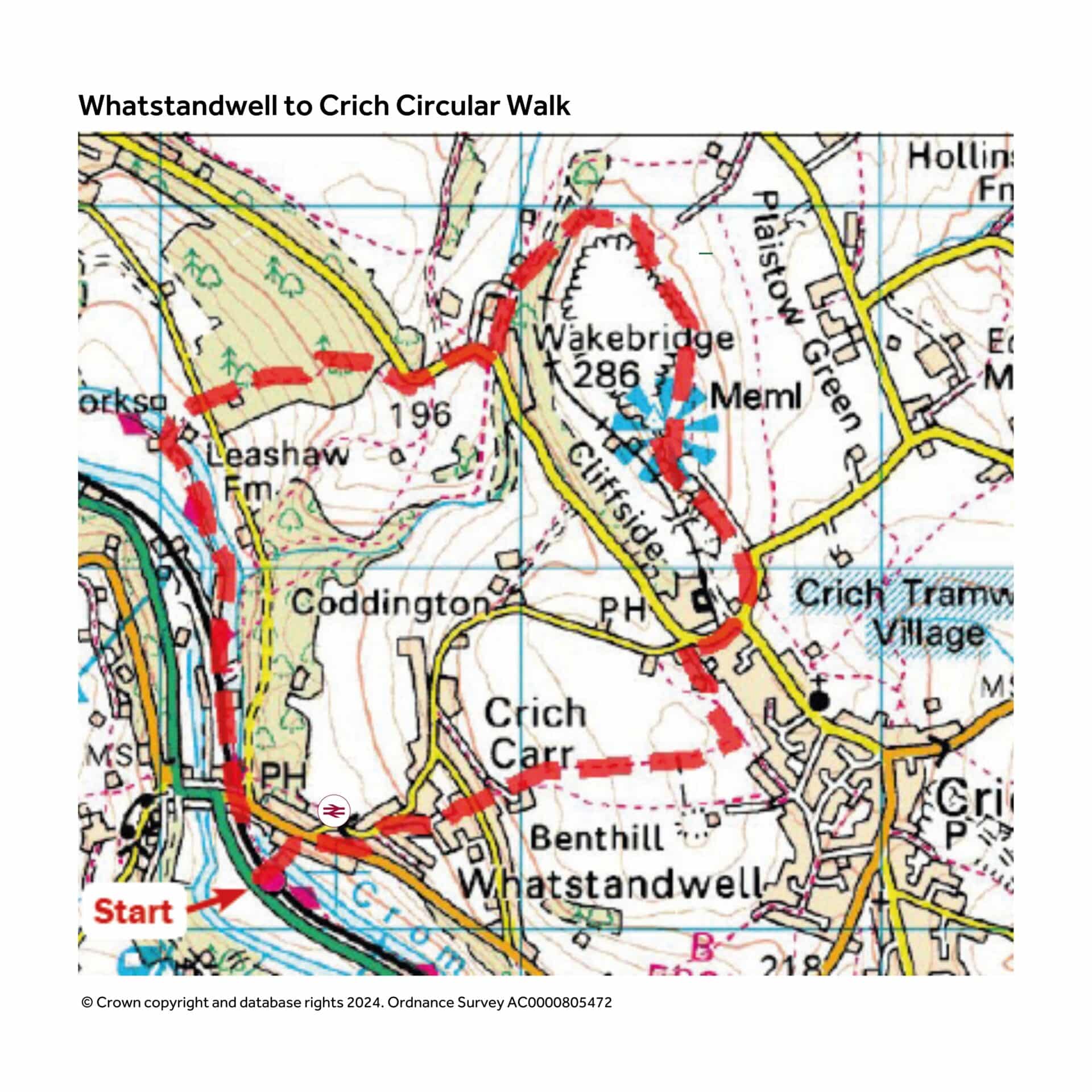
This 4 mile walk starts from Whatstandwell station. Refreshment options at Family Tree, adjacent to river bridge in Whatstandwell, Cliff Inn at Crich and Memorial Tea Room at Crich Stand. Other refreshment options in Crich village, slightly off the route.
From the station take the footbridge over the line which continues as the bridge over the canal. This public footpath was donated by the vicar as a direct route to the station and today offers a link to the canal.
Meet a road and cross with care into Hindersitch Lane opposite, signed as a route on foot to the Tramway Museum. The road is narrow and has no footway so care is needed. Follow the road for just 250 metres although it will feel a lot more. About 100m after Middle Lane the road splits either side of a house where a seat may encourage you to pause. Leave the ‘main’ road here and follow the track to the right of the seat. This leads onto Glen Road; follow this, still climbing, until at The Willows the road ends and our route continues as a footpath.
Steps finally lead on to Top Lane. A stone seat by a water trough offers another invitation to pause. Turn right along the lane then after 20m turn left between houses up a long flight of stone steps. The path finally emerges into open fields under the canopy of a beech tree. Continue through stone squeeze stiles with a view to the left of Crich Stand, the tip of Crich church spire ahead.
When Crich church comes into full view ignore the unofficial path left, and follow the path which heads towards a point just to the right of the church. Meeting a cross path marked by a stone gate post and the remains of a wooden finger post, turn left.
The path forks, here keep to the right through a stile by a gate. Ahead you will see the imposing facade of Derby Assembly Rooms at the Tramway Museum. At the road to your left is the Cliff Inn (open evenings only apart from weekend); turn right then a pause to watch the trams is worthwhile. It’s interesting to note that the trams run along part of a former tramway built to carry limestone. It passed under the road here and went down to limekilns alongside the canal at Ambergate. You can see the bridge and track bed on the opposite side of the road.
At the junction take the road left and when the footway ends a path has been provided along the field edge. This takes us to the approach road to the memorial; turn left along this. There is a tea shop here; check opening times in advance if you plan to stop. There is a charge to park but only an invitation to make a donation for those on foot unless you wish to climb the tower which is well worth 50p. Even without that extra climb the view is excellent so try and choose a clear day for this walk. There is also the Ordnance Survey ‘trig’ point behind the tower for those who wish to tick it off.
I’ve got a bit ahead of myself here because as the path approached the tower our path branched off right so either retrace your steps or follow the narrow but well walked path from the trig point. Either way our route becomes a surfaced path around the former quarry which is fenced to avoid accidents. There are occasional views left but over to the right the countryside is inviting across to the valley of the River Amber which flows out of Ogston Reservoir. The path bends round left until arriving at the upper terminus of the tram ride. There are picnic benches here if you wish to pause and watch a few trams.
Our journey continues by crossing the tram tracks and dropping downhill while bending to the left until meeting a metalled track at Wakebridge Farm. Continue along the track to the road. Cross with care and turn right to take advantage of the pavement. Ignore the first footpath and the second, even though the faded sign reads ‘Footpath to Cromford Canal’.
The pavement narrows and as the road bends right take the path left. At first enclosed by a fence on the left it then enters woodland. Continue downhill on the well-defined path. Cross the minor road and continue along the access track signed Leashaw Farm, where hidden among the buildings it crosses the canal. Turn right down steps to meet the towpath and turn right to pass under the bridge. Now follow the towpath back to the car park or beyond to the footbridge and Whatstandwell station.
Circular Walks on the Cromford Canal
This walk is kindly based upon a walk from Circular Walks on the Cromford Canal by Ken Brockway on behalf of Friends of the Cromford Canal.
This walking guide features short circular walks exploring the wonderful canal all the way from Langley Mill to Cromford.
The walking book is available from Friends of the Cromford Canal and local retail outlets.
Ken Brockway assisted by Keith Bailey and Hugh Potter have produced a book which offers twelve short circular walks taking you into some stunning countryside and perhaps places unknown to you.
There’s lots to see along the way; tunnels, including two you can walk through, and four aqueducts; one that takes water over water and another water over a railway.
There are two reservoirs, and the canal line passes through a large Nature Reserve.
There is a working lock taking boats from the Cromford to the Erewash Canal.
Friends of the Cromford Canal